Pacific Avenue Subarea Plan & Environmental Impact Statement – “Picture Pac Ave”

Contact
Wesley Rhodes
Senior Planner
(253) 208-0083
WRhodes@tacoma.gov
Project Study Area Map

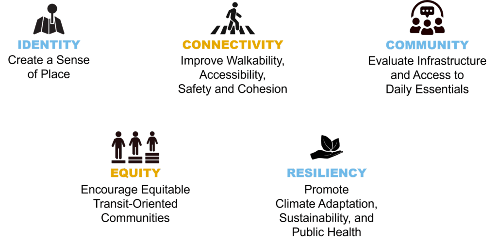
Guiding Principles
Outreach with the community as well as the Project Advisory Committee, City Commissions, and City Council during the Visioning phase helped develop the project’s overarching guiding principles.
Project Benefits
- Creates a community-shaped vision for the future of the corridor
- Advances City priorities such as housing affordability, economic development, and climate action
- Improves connectivity to planned transit improvements, businesses, and daily essentials
- Supports accessibility, including walking, biking, rolling, and ADA improvements
- Evaluates community needs such as parks, infrastructure, and other daily essentials
- Enhances zoning and standards for new development and infrastructure
- Identifies equity and anti-displacement strategies for existing residents and businesses
- Conducts upfront environmental review and streamlines future investments
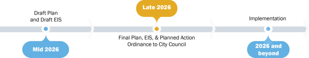
What’s Happening?
Currently under review is the project’s DRAFT Goals and Actions.
The project team along with the Project Advisory Committee are also drafting and reviewing chapters for the DRAFT Subarea Plan and the DRAFT Planned Action EIS to be reviewed by the Planning Commission and released for public review mid-2026.
Project Schedule
 Completed Documents:
Related Projects
While Picture Pac Ave is separate from Pierce Transit’s planned transit improvements along the corridor, the Plan will coordinate closely with Pierce Transit to enhance the benefits of these planned transit investments. This includes the roll-out of the Stream Community Line Enhanced Bus Service and continued coordination for long-range transit planning along the Corridor. Picture Pac Ave will consider how continued transit improvements can create opportunities for more housing and jobs near high-capacity transit stations. The Plan will also look for ways to improve transportation infrastructure and connectivity for people of all ages and abilities who walk, bike, and roll through the corridor.
Stakeholder Groups
-
City Council
-
April 25, 2023 – Presentation to the City Council Study Session
Agenda
VideoSeptember 8, 2022 – Council Members Bushnell, Ushka, and Walker attended a workshop to discuss the project’s engagement strategies
August 24, 2022 – Presentation to the City Council Infrastructure, Planning, and Sustainability Committee
Agenda
VideoMay 17, 2022 – Council Members Bushnell, Ushka, and Walker attended a kick-off workshop for the Subarea Plan
In addition to formal presentations, Council Members have been updated throughout the process through ad-hoc one-on-one informal meetings.
-
Planning Commission
-
Planning Commission agendas, minutes, videos, and presentation materials can be accessed here.
October 1, 2025 – Planning Commission workshop on the Subarea Plan Draft Goals
March 20, 2024 – Planning Commission presentation on the Draft Alternatives for the EIS and visioning and scoping summary
September 6, 2023 – Planning Commission presentation on the visioning and scoping summary
June 7, 2023 – Planning Commission presentation briefing on visioning and scoping
April 5, 2023 – Planning Commission workshop on engagement strategies
January 18, 2023 – Planning Commission early project workshop
November 16, 2022 – Planning Commission briefing
June 15, 2022 – Planning Commission briefing
-
Project Advisory Committee (PAC)
-
Project Advisory Committee Members:
Name Organization Alternate Laura Svancarek Downtown On the Go Katie Randall Mercy Housing Northwest Malcolm White Tacoma Public Library Gabby Fuentes Richard Gardner Tacoma Transportation Commission Andrea Haug South End Neighborhood Council Ralette Churchwell Larry Leveen Walk & Roll Pierce County Coalition Krystal Monteros Disability Rights Washington Anna Zivarts Lynette Scheidt ENACT Tara Scheidt Kim Eudaily Safe Streets (Larchmont) Lukas Barfield TACOD Raichle Dunkeld Active Transportation Advocate Vivian deZwager Tacoma Tree Foundation Herschel Wilson Energize Tacoma Troy Serad Planning Commission Chris Karnes Planning Commission April 13, 2026 – PAC meeting regarding the preliminary analysis as part of the Land Use and Transportation sections of the Planned Action Environmental Impact Statement
March 9, 2026 – PAC meeting regarding the Health Impact Assessment for the Subarea Plan
February 9, 2026 – PAC meeting regarding Draft Actions for the Connectivity section of the Subarea Plan
January 12, 2026 – PAC meeting regarding the Economic Prosperity section of the Subarea Plan and Mixed-Use Employment Zone
November 10, 2025 – PAC meeting regarding the Draft Actions for the Complete Neighborhoods section of the Subarea Plan
October 13, 2025 – PAC meeting regarding the Draft Actions for the Growth Strategy section of the Subarea Plan
September 3, 2025 – PAC (in person) workshop on the Subarea Plan Draft Goals
September 12, 2024 – PAC meeting regarding the Draft Alternatives and zoning for the EIS
April 15, 2024 – PAC meeting regarding the visioning and scoping process and concept Draft Alternatives for the EIS
May 4, 2023 – PAC meeting regarding the engagement plan
March 30, 2023 – PAC meeting regarding engagement strategies
February 9, 2023 – PAC Kickoff meeting
Resource Library
-
Environmental Impact Statement
-
The City will prepare a State Environmental Policy Act (SEPA) Planned Action Environmental Impact Statement (EIS), which allows for an upfront, cumulative, and area-wide evaluation of project impacts. As a result, future project-level permitting will be streamlined with greater predictability for the public and applicants.
The City issued a Determination of Significance (DS) and Scoping Notice in 2023. Click here to access the Determination of Significance and Scoping Notice.
-
Health Impact Assessment
-
The City partnered with the Tacoma-Pierce County Health Department to conduct a Health Impact Assessment (HIA). An HIA is a process that explores the impacts (either positive or negative) on public health of a proposed plan, policy, or capital investment, and helps shape recommendations and decisions based on these impacts.
-
Picture Pac Ave Subarea Plan Documents
-
- DRAFT Goals and Actions
- Land Use Alternatives Maps:
- Survey Results:
- Scoping and Visioning Presentation Deck
- Engagement Plan
- Baseline Conditions Report
-
Additional Relevant Materials
-
Key Plans, Studies, and Reports
- PSRC’s VISION 2050
- PSRC’s Regional Transportation Plan (RTP) 2040 and DRAFT 2050
- PSRC Centers Checklist
- PSRC Regional Economic Strategy
- Countywide Planning Policies for Pierce County
- Tacoma 2025: City of Tacoma’s Strategic Plan
- City Comprehensive Plan One Tacoma
- City Development Regulations
- Pierce County BRT Stream
- North Downtown Subarea Plan and EIS
- South Downtown Subarea Plan and EIS
- City Climate Action Plan
- Transportation Master Plan
- City Affordable Housing Action Strategy (AHAS)
- Home in Tacoma
- Puyallup Tribe Climate Change Impact Assessment and Adaptation Options Study
- Pierce County Buildable Lands Report (2021)
- Parks Tacoma Strategic Master Plan (2018)
- Pacific Avenue Creative Place-Making Project – Livable City Year Program
- Transit-Oriented Development Advisory Group (TODAG) TOD Toolkit
- City of Tacoma Equity Index
- Transfer of Development Rights Program:
- Tacoma-Pierce County Health Department’s Healthy Community Planning Toolbox and Guide to Integrate Health into SEPA Review
Concurrently developing plans and regulations:
-
Picture Pac Ave is described as a Subarea Plan, what is a Subarea Plan?
A Subarea Plan is a long-range comprehensive plan for an area of the City where future growth and development is expected and/or desired. It provides a process to work with the community to create a long-term vision and identify the steps necessary to achieve that vision, over time.
Picture Pac Ave will support existing and future transit improvements and help plan for additional growth and development along Pacific Avenue over the next 25 years. Subarea plans are considered comprehensive because they generally include sections covering a range of topics such as land use and zoning, transportation, economic development, urban design and placemaking, infrastructure, sustainability, and more.
Why is the City conducting Picture Pac Ave?
In 2019, the Tacoma City Council passed Resolution No. 40287, affirming the City’s commitment to developing a comprehensive subarea plan for Pacific Avenue. The plan will create a long-term vision for growth and identify action steps, such as code and policy changes, as well as priority investments for infrastructure and public services and facilities, that will achieve this vision over the coming decades.
This type of planning work helps the City better support and accommodate both future capital investments and projects as well as growth and development along the Corridor, including future transit improvements.
How will this impact the Pacific Avenue Corridor in the next five years? How will recommended improvements be funded and implemented?
Picture Pac Ave is a long-range plan by design. This means that the Plan outlines implementation steps to achieve the community-shaped vision over a 25-year period, out to 2050.
However, the plan will contain actions and projects that could be implemented within the first five years after adoption. Some of these actions may include new land use and zoning regulations, new development regulations such as building standards and design guidelines, public realm improvements, and additional “low hanging fruit” or “quick win” opportunities as well as a means of prioritizing projects and investments based on community priorities, such as safety.
While it is important to note that Picture Pac Ave does not currently have funding for implementation, inclusion within the plan has the potential to make identified projects more competitive for funding both within the City budget process as well as for external grants and funding sources. The plan will include information about potential funding sources within an implementation section.
How will this impact my access to things like parks, groceries, community centers, libraries, and other important services along Pacific Avenue?
Traditionally, these types of facilities and services have been referred to as “amenities,” however, Picture Pac Ave considers them “daily essentials.” Goals and actions within Picture Pac Ave will support safe and convenient access to these daily essentials for all neighborhoods along the corridor, a concept known as “complete neighborhoods.”
How are decisions made throughout the Plan development process? How are you engaging the public and using public feedback?
Picture Pac Ave is conducting extensive engagement along the corridor with the public and works through a Project Advisory Committee (PAC) with community and organizational stakeholders that meet regularly to guide the work.
Picture Pac Ave takes a varied approach to outreach with an emphasis on meeting folks where they are. For example, City staff have attended over 20 in-person community events, including walking the entire corridor, and riding the bus, with the community over the span of four separate community walks in partnership with the South End Neighborhood Council (SENCo).
City staff have attended community events at parks, schools, libraries, farmer’s markets, block parties, bike rodeos, and community cleanups, among others, to speak with folks about their vision for the Pacific Avenue Corridor. As a youth engagement strategy, the project has partnered with both Stewart Middle School and University of Washington Tacoma’s “Action Mapping Project” (AMP).
Virtual participation methods are also employed. The project launched an Online Open House for its “visioning” phase, which was fully translated into Spanish, Vietnamese, and Korean. The Online Open House contained both a survey and an ideas wall for the community to share their vision for the Corridor. A virtual Open House Meeting was also held during the visioning phase.
Picture Pac Ave continues to use Cultural Language Ambassadors to expand participation to Spanish and Vietnamese community members. Ambassadors have provided guidance on the cultural appropriateness of outreach materials and translations, have collected survey responses from the community, and attended public meetings to provide interpretation services and encourage attendance of these events from a more diverse and representative group of community members.
Public feedback from the “visioning” phase of the project was used to develop the project’s five Guiding Principles. Feedback during the Draft Plan and Draft EIS development ensure those principles form the foundation for the project’s subsequent EIS Alternatives, goals, and actions. The public will have an opportunity to comment on the development of those Alternatives, goals, and actions during an in-person Open House on Saturday November 15, 2024, at the Tacoma Public Library Moore Branch.
Once draft versions of the Plan and EIS begin the Planning Commission and City Council review process, there will be additional opportunities for public comment throughout.
Why is the City conducting an environmental review as part of this process?
In addition to the Subarea Plan, the City is also conducting a Planned Action Environmental Impact Statement (EIS) for the Corridor. This process will help the City understand the potential impacts of future growth and development along the corridor as well as identify potential measures such as capital investments (potential projects in the area) and code and policy changes to help mitigate those impacts.
A Planned Action EIS allows for an areawide, cumulative analysis as opposed to a more piecemeal project-by-project approach to environmental review. Conducting this analysis upfront can streamline future development and provide more certainty for developers and the public.
Project level review for many aspects of future developments will still occur. Future housing projects that take advantage of streamlined environmental review will also be subject to mandatory affordable housing provisions.
Why has the City partnered with the Tacoma-Pierce County Health Department to conduct a health impact assessment (HIA) as part of this process?
The Tacoma-Pierce County Health Department chose Picture Pac Ave as part of its series of pilot health impact assessments (HIAs) in partnership with the City of Tacoma. HIAs offer a process to work alongside community members to identify and assess the public health impacts of a proposed project, policy, or plan.
The HIA was conducted early in the Picture Pac Ave process and as such identifies possible health impacts of the project and provides high level recommendations to inform the project’s adopted goals and actions and enhance positive health impacts. The HIA will serve as a supplement to the environmental review through its focus on public health.
How are you working with Pierce Transit to improve future transit along Pac Ave?
Pierce Transit is a key partner and has partially funded Picture Pac Ave. The City and Pierce transit are working closely along with other key transportation agencies such as the Washington State Department of Transportation (WSDOT) and Sound Transit to create a unified vision for the corridor and ensure that the goals and actions identified in Picture Pac Ave support safe and reliable connectivity for users of all modes and of all ages and abilities along the corridor. The plan will also work to support existing and future transit improvements along the corridor, such as Pierce Transit’s Stream Community Line and station area improvements.
How is the Plan taking into consideration potential future annexations?
Pierce County is a key stakeholder for Picture Pac Ave. While Picture Pac Ave is focused on the portions of Pacific Avenue within Tacoma City Limits, it immediately abuts the Parkland/Spanaway Potential Annexation Area (PAA). The City will continue to explore ways to coordinate planning with the County for the City’s PAAs and identify goals and actions within Picture Pac Ave that might have applicability to, or benefit within, those PAAs.