Bridge Industrial Warehouse Project
Contact
Noah Yacker
Project Coordinator
nyacker@tacoma.gov
Project Timeline
-
Permitting, Public Review, and Appeal Process (2021-2023)
-
Project developers first applied for permits in mid-2021, and the public review process began in early 2022. A permit decision on April 21, 2023, was appealed to the City’s Hearing Examiner, who upheld the decision on October 5, 2023, determining that the proposal was compliant and could proceed as long as multiple conditions were applied to the project.
View the Tacoma Hearing Examiner’s Findings of Fact, Conclusions of Law, and Decision.
-
Initial Site Work Begins (2024)
-
Initial site work began in early March of 2024, including setting up erosion control and wetland protection, with grading, filling, utility installation, and paving work coming soon after.
-
Construction (2024-2025)
-
Civil work including soil compaction, finished grading, utilities and paving are underway and take several months. Building construction is in process and nearing completion.
-
Complete Project (2025)
-
The proposed buildings are all about 40 feet in height, with loading docks on two sides and office spaces / pedestrian entries on both corners. (Building D only has truck loading on one side.) The buildings will be concrete with glass windows at the corners. Buildings will have metal siding accents. In short, the buildings will look like other warehouse buildings in the region.
To see the permit applications and status for the project, visit our Customer Access Portal and enter parcel 0220131132 into the search field on the upper right. You do not need a permitting account to view active permits.
Frequently Asked Questions
What will the buildings look like when the project is complete?
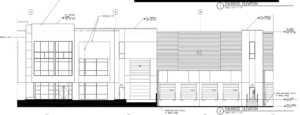
The proposed buildings are all about 40 feet in height, with loading docks on two sides and office spaces / pedestrian entries on both corners. (Building D only has truck loading on one side.) The buildings will be concrete with glass windows at the corners. Buildings will have metal siding accents. In short, the buildings will look like other warehouse buildings in the region. The buildings are designed to be “solar ready” so that tenants may add solar infrastructure should they choose to do so.
What will the site look like when complete?
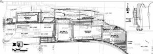
The main part of the site (outside the wetland and forested hillside) will be mostly buildings, surrounded by passenger vehicle parking and truck/container areas. The central portion of the site is a good example:
Passenger vehicle areas and the perimeter of the site will be. The site includes a “through street” from South Burlington Way to South 35th Street, connecting the site to the Sounder Station and the neighborhood to the south with a 10-foot sidewalk and street trees between the buildings and the railroad tracks. An approved landscaping plan is available in the Land Use file LU21-0125. (Visit our Customer Access Portal and enter LU21-0125 into the search field on the upper right. You do not need a permitting account to view this permit and attachments.)
What conditions did the City place on the permit for this project?
Based on information gathered in its State Environmental Policy Act (SEPA) review, the City placed conditions on the permit. These conditions must be related to the environmental impact of a project and meet the requirements of Washington state law. In this case, the City placed conditions on the permit relating to air quality and greenhouse gases; urban forestry and vegetation; environmental health; and traffic condition monitoring, intersection modifications, new signals, street connections and sections.
How will the developer protect the environment and sensitive wetlands on the site?
Prior to approval of development permits, the applicant was required to complete the associated environmental review in compliance with the State Environmental Policy Act (SEPA), and complete a Critical Areas Permit related to the wetland and forested area on the western portion of the site.
The Critical Areas Development Permit decision was “approved with conditions,” which means the project has been reviewed for compliance with the Tacoma Municipal Code for critical areas and, if built with certain conditions, the development may be approved. Conditions include:
- Completing restoration, enlargement, and enhancement of the wetlands and stream
- Protecting the Garry Oak trees on site and providing excess plantings to compensate for the one being removed
- Preserving and enhancing the steep slope and treed areas on the western portion of the site
- Recording these protections permanently on the title to the property, and recording a Conservation Easement for the protected area
- Providing long-term monitoring of all plantings for 10 years until they are well established
The associated SEPA Environmental Determination is a “Mitigated Determination of Nonsignificance,” (MDNS) which means the project, as revised and with the additional studies that have been reviewed, is not likely to have a significant adverse impact on the elements of the environment that are reviewed under SEPA, as long as the project meets certain conditions (mitigation) for the impacts. Mitigation under SEPA includes the following (with status as of the third quarter of 2025 included):
- Clean-fuel construction equipment and no-idling rules on the site
- This is a condition of operation of the site and will be reviewed with tenant improvements and business licensing once the site is ready to be occupied
- 30% tree canopy coverage on the development portion of site, with payment in lieu of plantings for a portion of the tree provision
- The approved landscaping plans have been reviewed for compliance with this condition and proposed tree canopy coverage on site is approximately 26%; payment of the fee in lieu is pending and will be verified prior to any building occupancy.
- Traffic monitoring as the site is built out, with caps on the amount of trip generation allowed under the current environmental review and mitigation
- This is an ongoing condition of monitoring and tenant improvements / building occupancy.
- Construction of a new north access road for trucks to reach South 35th Street, intersection improvements at 35th and Union
- The developer is coordinating with the City of Tacoma and Tacoma Water to finalize construction of the North Access Road and to complete the construction drawings for improvements to South 35th Street. This road must be open and operational prior to permanent occupancy of any of the buildings.
- Improvements to South Madison Street
- Improvements to South Madison are underway, associated with development. These improvements must be complete prior to permanent occupancy of any of the buildings.
- Public bicycle and pedestrian path along the north-south road
- The north-south road consists of Burlington Way along the frontage of the site, connected to the North Access Road and South 35th. Improvements are underway for the majority of this road as development progresses; the road and pedestrian facilities must be open and operational prior to permanent occupancy of any of the buildings
- Pedestrian improvements (sidewalk connections, rail crossing, bicycle lanes) on several streets and at several intersections
- These facilities are located along public right-of-ways adjacent to the site (for example, along the north side of South 50th Street). These improvements must be complete prior to permanent occupancy of any of the buildings.
These improvements must be in place or paid for before any of the buildings may be permanently occupied.
What legal challenges have there been against the project?
There have been two notable challenges against the project.
- The permit was issued April 21, 2023, and was subsequently appealed to the City’s Hearing Examiner. The appeal hearing concluded on August 4, 2023. Recordings of the hearing are available through the Hearing Examiner’s Office. Read the Hearing Examiner’s decision that was issued October 5, 2023. The full land use permit can be accessed from https://aca.accela.com/TACOMA/Default.aspx by entering “LU21-0125” in the search field. Documents are located under the “Record Info” tab. The documents are the files that are part of the project record, which were used in making these decisions. Documents that are not part of the record have been archived.
- In December 2023, The Washington State Department of Ecology issued the project coverage under the Construction Stormwater General Permit (CSGP)which included an administrative order with the project’s permit coverage. This order had conditions Bridge Point Tacoma had to follow to protect water quality when working on a contaminated site, as well as conditions to mitigate air quality and traffic impacts from diesel trucks. Bridge Point Tacoma appealed its permit coverage and the traffic and air-quality related conditions in the administrative order, although both the order and permit coverage remained in effect during the appeal process.
On November 21, 2024, and as part of an initial settlement agreement, Bridge Point Tacoma agreed to withdraw its appeal and pay Ecology $8.95 million to address traffic and air pollution in South Tacoma. The Department of Ecology will gather community input on how the settlement funds should be used to best address air quality and traffic concerns through mitigation projects.
The Department of Ecology staff will make the final determination about how to utilize the funds in compliance with the settlement agreement. Again, Ecology indicated they will coordinate with the City and other agencies in conducting community outreach, but City staff will only have a supporting consultation role and will not be leading this process.
Learn more about the settlement and what happens next.
How will the groundwater on site be protected?
Any water that isn’t surface water will infiltrate into the groundwater—in other words, any runoff from the site that isn’t directed to the stream will seep into the soil and become groundwater. The stormwater system is designed to collect the runoff, filter it, and allow it to disperse back into the stream or into the ground.
Is the Council going to look at zoning in the South Tacoma Groundwater Protection (STGP) District?
Yes. For more information on recently-adopted changes to the STGPD, visit the South Tacoma Groundwater Protection District project web page. While the current Bridge development is reviewed under the laws in place at the time of permit application, future permits at the site will be reviewed under the updated rules in place at that time.
How will developers safely handle contaminated soil at the site?
A portion of the site has been remediated in the more than 20 years ago through CERCLA (Federal EPA Superfund program). Contaminants were placed on a capped portion on the north side of the site. This portion of the site is part of the proposed light industrial and warehouse development.
As part of the cleanup, the owners (and subsequent owners) are party to an agreed order and institutional controls for the site and will continue or complete remediation as part of redevelopment. Under the review and authority of the EPA and the Department of Ecology, they will have specific work plans, worker training, and contractual obligations for work on that portion of the site.
How do the traffic conditions work?
The site is designed so that big trucks are directed toward the north, to the closest access for SR16, and away from South 56th Street and South Tacoma Way. The site is also designed so that business parking stays on site, with spots for about 1,250 cars plus parking and storage for trucks and trailers.
Street improvements will need to be finished before the buildings can be used. When buildings are inspected for occupancy (meaning a user can open the business, have employees/customers, etc.) one of the checklist items is completion of required mitigation. This means that buildings cannot be used until, for example, the intersection at South 35th Street and South Union Avenue is completed.
The traffic mitigation requirements for this site were based on estimates of how many vehicle trips future tenants would generate. Because the exact mix of tenants isn’t known until the buildings are leased, the Traffic Impact Analysis (TIA) used a conservative approach to estimate future traffic assuming a general “Industrial Park” land use type. To ensure actual traffic matches these estimates, the applicant must monitor and report the mix of tenants to the City when the buildings are 50% leased and again at 75%. This helps confirm that the tenants are consistent with the types of land uses assumed in the TIA. If a tenant falls into a category known to generate more traffic, such as a “High-Cube Parcel Hub” or a “High-Cube Fulfillment Center (sort)”, a new traffic study will be required. If that study shows traffic exceeds the original estimates, the developer will have three months to work with tenants to reduce trips. If traffic still exceeds the estimates after a follow-up study, the developer may be required to build additional improvements (mitigation) at key intersections to meet the City of Tacoma’s traffic level of service standards.
(Visit our Customer Access Portal and enter LU21-0125 into the search field on the upper right. You do not need a permitting account to view this permit and attachments.)
What will happen with the wetland?
The stream at the base of the hill, the wetlands that are associated with the stream, and much of the adjacent forested hillside are all protected areas under the City’s Critical Area Protection Ordinance. The applicant is required to restore and protect these areas forever by placing restrictions on the property title for the site.
Once development permits are approved, the owner will start removing debris and invasive plants from the area. Then the wetland area will be enlarged and the entire vegetated area will be replanted and maintained with native plants. The property owner is required to report to the City every year for ten years about the maintenance and survival of the plants and the conditions of the stream.
Outside of the stream/wetland, the site is designed so that any runoff from buildings or paved areas will maintain the amount of water in the stream, and that the water entering the stream is clean of any contaminants.