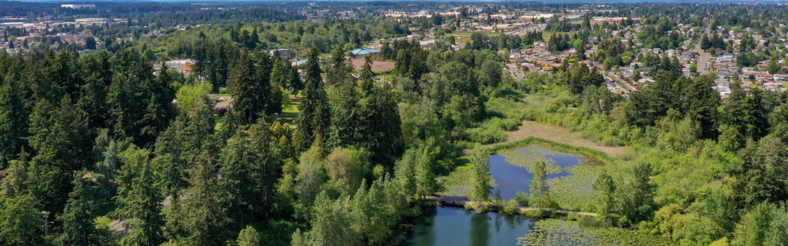
Open Space Program
Our Open Space Program focuses on conserving, activating, and managing open spaces and urban forests in alignment with City policies and regulations. Restoring and preserving these lands is considered critical to the health and wellbeing of our community. Here you can learn more about how we manage the City’s open spaces, why they’re important, and how you can get involved.
What Are Open Spaces?
City Open Spaces refer to areas within urban environments that are set aside for recreation, conservation, and environmental management. These spaces include parks, forests, wetlands, greenbelts, trails, and other undeveloped or lightly developed areas. These spaces are categorized into two types:
- Passive Open Spaces: Natural, undeveloped areas like forests, steep slopes, or wetlands that are preserved for ecological benefits and limited human use. These are managed by the Open Space Program.
- Active Open Spaces: Developed areas designed for community access and recreational use, like sports fields or playgrounds. Active open spaces in the City of Tacoma are managed by Parks Tacoma and the City’s Real Property Services and Public Works.
The Open Space Program does not manage any active open spaces.
Managing Passive Open Spaces
The primary goal for passive open spaces is to establish native species-dominated, sustainable plant communities and forests. These areas are regulated under the City’s Critical Areas Preservation Code and many of them require management plans to address improvements in critical areas like wetlands and steep slopes. These plans vary in scope based on ownership, existing conditions, and community input.
Currently, the City manages about 515 acres of passive open spaces. In 2014, the management of passive open spaces was transferred from City Planning and Development to Environmental Services to better preserve natural areas, increase vegetation diversity, reduce overabundant weed species, and enhance stormwater benefits.
Benefits of City Passive Open Spaces
- Environmental Health: They play a crucial role in maintaining ecological balance by preserving natural habitats, improving air and water quality, improving stormwater quantity and quality, and increasing tree health and canopy cover.
- Community Health and Well-Being: Access to green spaces offers stress relief and mental relaxation, enhancing overall well-being for city residents. Additionally, increased tree canopy cover can reduce the impacts of heat islands, cooling temperatures during heat events.
- Community Connection: Open spaces foster social interactions, bringing community members together for events, volunteer activities, and shared outdoor experiences.
- Educational and Stewardship Opportunities: Open spaces offer hands-on learning experiences about the environment and encourage community members to participate in conservation and restoration efforts.
- Workforce and Development Opportunities for Youth: primarily through the Washington Conservation Corps, who maintain and steward City open space properties.
- Low Impact Recreational Opportunities: Passive open spaces provide areas for activities such as walking and bird and wildlife observation, promoting healthier lifestyles
- Aesthetic and Economic Value: These areas improve the visual appeal of urban environments and can increase property values in surrounding neighborhoods.
By integrating natural areas into the urban landscape, city passive open spaces enhance quality of life and helps support long-term sustainability for communities.
Open Space Plans
-
The Puget Sound region is known for its dynamic coastline, featuring over 1,400 miles of beaches formed from sand and gravel eroded from nearby bluffs. Schuster Slope, located along the west shore of Commencement Bay in Tacoma, is one of these actively eroding bluffs, playing a vital role in our coastal ecosystem. It supports coastal forests, nesting birds, raptors, native wildlife, and supplies sediment to nourish our beaches.
Site Conditions
Schuster Slope experiences frequent skin slides, debris flows, and sloughing due to the lack of healthy vegetation on its steep slopes and consistent rainfall. These natural processes reflect the bluff’s gradual return to its original state as a natural feeder bluff. Slope stability has been studied in two City-led investigations conducted by GeoEngineers, first in 2000 and again in 2014. The Bayside Trail, part of the Schuster Parkway Trail system, was closed in 2000 due to concerns about slope stability, ADA accessibility, and emergency access.
Critical Area Designation
Schuster Slope is classified as a Critical Area under Tacoma Municipal Code13.11 because of its steep slopes, wetlands, streams, and priority habitat, as identified by the Washington Department of Fish and Wildlife. To ensure effective long-term management and slope stability, a 20-year permit under the Critical Areas Preservation Code will enable the City’s Environmental Services to carry out restoration actions efficiently.
Additional Resources
-
Mason Gulch is a 36-acre open space in North Tacoma, featuring steep, forested slopes that surround a wetland and creek complex at lower elevations. This area offers crucial environmental benefits, such as stormwater management, wildlife habitat, and water quality protection.
Historical Significance
The creek that runs through Mason Gulch once served as a water supply for North Tacoma residents from the late 1800s until the 1920s. In 1926, Tacoma Public Utility’s Water Department purchased the property with plans to use it as a water source, but a hydrologic report in 1964 revealed that geological and soil challenges would complicate its use for that purpose.
In 1966, the North End Sewer Treatment Plant was constructed at the mouth of the gulch, and the plant continues to use creek water in its sewage processing. In 2014, the property was transferred to the City of Tacoma’s Environmental Services Department, which now manages the area with a focus on improving surface water quality and vegetation management.
Landscape Management Plan
In 2019 the City developed a Landscape Management Plan (LMP) to ensure responsible stewardship of Mason Gulch. This plan aims to balance slope stability, forest health, public safety, and scenic views while adhering to regulatory requirements.
Additional Resources
Mason Gulch Landscape Management Plan
-
Salmon Beach Slope is a 3.77-acre, steeply sloped passive open space located near the west shore of Puget Sound in Tacoma. This area is classified as a Critical Area under Tacoma’s Critical Areas Protection Ordinance (TMC 13.11) due to its steep slopes and priority habitat for terrestrial animals as designated by the Washington State Department of Wildlife (WDFW). The site is also recognized as both an “Erosion Hazard Area” and a “Landslide Hazard Area” under the City of Tacoma Land Use Regulatory Code. Approximately 60% of the area has slopes exceeding 40%. Currently, here is little evidence of surface erosion and no recent deep-seated slope instability has been observed.
The dominant tree species on the slope include native Big Leaf Maple, Douglas fir, and Madrone. However, decades of tree topping to maintain water views for nearby homes has led to die-back, diseased trees, and the spread of invasive shrub and groundcover species.
Timeline of Key Events
- 1979: The Salmon Beach Slope was designated as passive open space to mitigate the impact of the Parkside Development at the top of the slope.
- 1995: The Parkside View Management Plan was implemented, with plans to update it to meet current regulations and standards.
- 2014: Environmental Services (ES) took over property management, funded by a utility rate increase. ES manages passive open spaces to improve stormwater quality and reduce runoff through ecosystem services.
- 2017: A 20-year Landscape Management Plan (LMP) was permitted, aiming to restore native vegetation and enhance ecosystem services.
Restoration Goals
Environmental Services has six specific goals for managing the Salmon Beach Slope:
- Achieve a sustainable ecosystem
- Maintain slope stability and reduce erosion
- Improve wildlife habitat
- Maximize stormwater benefits
- Protect public infrastructure and safety
- Address Vegetation Modification Requests for Private View Management
These goals are focused on fostering a diverse, healthy forest ecosystem that supports long-term sustainability and environmental health.
Additional Resources
-
Julia’s Gulch is a 31.66 acre, steep sloped passive open space ravine located in Northeast Tacoma, home to diverse forest vegetation. While no streams or wetlands are on site at Julia’s Gulch, runoff from the gulch flows into the Hylebos Waterway, which is important fish habitat.
Additional Resources
-
First Creek is a vital natural landmark in East Tacoma with historical and cultural significance, especially to the Puyallup Tribe. Spanning a drainage basin of approximately 2,500 acres, the creek is home to diverse wildlife and vegetation, serves as a stormwater management function, and includes both public and private lands. Over the years, development and neglect took a toll on the creek.
Community Partnership and Planning
In 2011, community members collaborated with the City of Tacoma, the Puyallup Tribe, the Tacoma Housing Authority, and other agencies to create a comprehensive plan to restore and enhance the First Creek corridor in East Tacoma. Led by a Stakeholder Committee of public agencies, community groups, and property owners, the plan was shaped through public workshops and supported by a Forest Habitat Assessment Report.
Status of the First Creek Action Plan
In 2013, the First Creek Action Plan was published and provided a community-driven vision for preserving and enhancing the creek as an open space, recreational area, and environmental asset. Objectives included habitat restoration, debris removal, improved public access, water quality enhancements, and empowering volunteers.
The plan outlined a five- to ten-year roadmap for action, identifying key public and community partners to lead various initiatives. Though progress depended on available resources, the plan ensured that all stakeholders had a coordinated approach to achieving the shared vision.
Milestones and Improvements
Substantial progress has been made, including the removal of tons of garbage, the replacement of invasive plants with native species, and the installation of new signage to raise awareness about the creek.
A significant milestone was the renaming of the creek from “T Street Gulch” to “First Creek” to highlight its cultural significance. Historically, this was the first creek reached when canoeing up the Puyallup River. Community activists promoted changing the name to “First Creek” to better identify it as an important community asset.
Ongoing Project: Invasive Species Removal
The City has initiated the removal of knotweed, an invasive species, from the stormwater channel between East 40th and East 48th streets along Portland Avenue. Native plants will be introduced along the creek banks once the knotweed is eradicated. This ongoing project is part of the broader effort to restore the First Creek ecosystem.
Additional Resources
First Creek Action Plan – 2012
Tacoma Habitat Stewardship Program
Launched in 2025 in partnership with the Pierce Conservation District, the Tacoma Habitat Stewardship Program (THSP) engages the community in caring for Tacoma’s urban natural areas. These spaces are vital for clean air, water, wildlife, and community health. All skill levels welcome!
Learn More About the Program Here
Frequently Asked Questions
-
The City’s open space program is intended to conserve, activate, and manage open space and urban forest lands consistent with City policies and regulations.
-
The City has segregated its open space into two categories: active and passive. Active areas are those that are developed primarily for community access and recreation. These include parks, play fields and boulevards such as Ruston Way. Passive properties are generally undeveloped and covered with vegetation; many are regulated by the City’s Critical Areas Preservation Code; and most provide or have the potential to provide benefits to stormwater quantity and quality. The distinction of “active” vs. “passive” on any property does not exclude an active function on a passive property or vice versa but more clearly defines departmental roles and funding. Responsibility for maintenance and operations is shared amongst many City departments.
-
Active open space properties are developed primarily for community access and recreation and include areas that are hardscaped, landscaped, and formalized. These areas are maintained and operated by the City’s Public Works and Real Property Services Departments.
-
Passive open space properties make up approximately 488 acres of City‐owned forests, wetlands, streams, and habitat areas. Naturally vegetated and functioning ecosystems provide many environmental benefits to people as well as animals. Healthy forested lands absorb and reduce the amount of rain runoff, which would otherwise require large scale and costly engineered stormwater systems to manage. Because of the stormwater benefit, the City’s Environmental Services Department maintains and manages the passive open space properties.
-
Management of passive open space properties is primarily funded through surface water utility fees because of the stormwater benefits – improved water quality and reduced runoff volume – provided when natural areas are fully functioning.
-
Individual properties are grouped together into larger management units based on geographic location, hydrologic connections, and vegetative condition. These management units are then assessed using the Forest Landscape Assessment Tool (FLAT). This rapid assessment method gathers quantitative data on vegetation which is used to characterize and prioritize management units. Many factors determine the next steps for any one property, the City’s more complex properties may need a Landscape Management Plan and/or permits to move forward.
-
Landscape Management Plans are prepared and used to define and direct allowable long‐ term management activities for a property with regard to improvements, maintenance, process and any permitting requirements. Open Space Landscape Management Plans identify the “target ecosystem” and what steps and resources are required to achieve this goal. When open space areas encompass critical areas (i.e., wetlands, buffers, steep slopes), management plans are required and must be permitted per local, state and federal laws. Common management activities (which could require a permit) include but are not limited to:
- Planting native vegetation
- Pruning or removal of vegetation
- Installation of permanent structures
- Filling or excavation of soil
- Exposing a large area of bare soil